Planning and cadastre
National Land Commission Secretariat
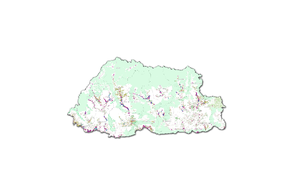
Land Use Land Cover 2020 Category: Open
The Land Use Land Cover (LULC) 2020 map of Bhutan highlights major land cover types, with forests dominating at 69% (a slight decrease from 2016). Other significant categories include Snow and Glacier (4.83%), Shrubs (4.11%), and Alpine Scrubs (8.89%, up from 3.39% in 2016). Minor covers include agriculture (2.96%), water bodies (0.61%), and built-up areas (0.25%). The map has an overall accuracy of 87% (kappa 0.853).The Sentinel-2 imagery, acquired from ESA's Copernicus Open Access Hub, underwent several pre-processing steps. The image classification was carried out using random forest technique using the e-cognition software.
Keywords: [#lulc#agriculture#built up#forest#grassland#barren land#glacier#snow#water#landslide#vegetation#meadow]
National Land Commission Secretariat
National Land Use Macro Zones_Baseline2023 Category: Open
This dataset presents the consolidated macro-zone layers derived from the NLUZ Baseline 2023. It integrates sectoral datasets from multiple agencies and includes eight major land use macro zones: Agricultural Land, Rural Settlement, Sustainable Forest Management Area, Nature Conservation Area, Industrial, Cultural Heritage, Urban, and Rangeland. It also incorporates key right-of-way buffers such as highway buffers, transmission line buffers, and flight funnel buffers. The dataset represents a generalized macro-level spatial output of the NLUZ Baseline 2023 consolidation exercise.